As is tradition here (read: something I did once) I thought hey, how about I climb up this really tall mountain tomorrow?
I still had a few days before work would start again, and I've been wanting to climb Mount Fuji, Japan's tallest mountain, for years already. The problem is, Mount Fuji is an incredibly popular tourist destination and you'd have to book months in advance if you wanted a place in one of the huts anywhere on the mountain, in the short timeframe from July to August where it is open. Additionally, there are no ropeways to the top like in the case of the Zugspitze, so you'd have to ascend and descend it all yourself, making day trips seem unrealistic.
Or so I thought, until I looked it up, and realized a day-trip is actually very realistic! So I stocked up on supplies, packed my backpack and set my alarm to 5:00 the next day.
Itinerary
There is a bus that goes straight from the Shinjuku bus station (Busta) to Fuji-Subaru Line 5th station (富士山五合目), highest point of the Yoshida (吉田) trail that is reachable by motorized means. The Yoshida trail is the most popular one of the four trails to the top of the mountain, and the easiest to access and do in a single day, so I went with the basic option here.
The bus leaves Shinjuku at 6:45 and reaches the station at 9:20 for 3,800¥. This is the earliest bus to the trail head, so you cannot go earlier by public transport, unless you take the overnight bus. The bus itself is very comfy and easy to sleep in. The last return bus to Shinjuku Busta from the trail head leaves at 16:45, so you have about 7.5h to climb Fuji. If you don't make it, there are still buses for another 2h down to Kawaguchiko (one of the five Fuji lakes) where you can either take one of the always-booked out buses to Shinjuku, or take the Takao trains for another 3h to get back to Tokyo.
If you want more details on possible transport options, hiking routes and itineraries, I originally got my information from an amazing blog article at Emma Goto which I highly recommend for an overview.
The Ascent
I got up at 5:00 in the morning, finished my prep, then trained to Shinjuku station. I arrived at the bus stop 5 minutes before the bus left, panicked a bit when I realized you had to buy a ticket for a seat, was very relieved that there were still free seats left, then got on the bus and slept until we reached the station. I had the row to myself, but I also went on a weekday, so YMMV. The bus got there about half an hour early, so at 9:00 I was ready to start my hike.
Once you arrive at the 5th station, there are a couple shops to stock up on food and drinks if you have not prepared responsibly, and also public toilets. This is your last chance to go on a proper, sanitized and free toilet. After this, it's all paid, stinky mountain toilets. Next, I had to pay the trail entrance fee - apparently a new thing they introduced quite recently, rather expensive at 4,000¥.

After that, it's off to the trail.
I got quite confused right away, since there were a lot of people coming my way and not many going the same direction as me, as well as the trail going ever so slightly downward, so I ended up asking one of the hikers passing me by, whether I was headed in the right direction. THey kindly confirmed that this was the right way, and soon afterwards we started going up.
I didn't take many pictures of the start of the trail, as it is really just a boring gravel path. But since the bus station is at 2,300m elevation, you already get very nice views of the surrounding Yamanashi prefecture and the Fuji lakes.

I took a bunch of pictures of the view, until after half an hour I arrived at the first notable incline.

Suddenly, the difficulty increases drastically. Though not too long after, the path flattens significantly again, and for the better part of an hour, it is a slow trot up the path, alternating between steep but even gravel paths, and rocky bits that feel a lot like stairs with very uneven steps.

For fun, I measured my heartrate towards the start of the hike. Nothing fancy, just running down a 10 second timer while counting, then multiplying by 6. Until I reached the peak, my heartrate was almost constantly 180. This didn't change at all over the course of the entire trip, it didn't even decrease significantly during my breaks.
I usually find it very difficult to tell from photos how steep inclines are, but it really helps give you an idea when there are other people in the picture.

As you'd expect from Mount Fuji, even on an early Tuesday morning, there are a lot of people around. It wasn't super full by any means, but it is very rare to have a moment where you can't see another person within 30m of you. There are also mountain huts every 20 or so minutes of hiking, meaning that overall, you feel very safe on the way.

At some point perhaps one or two hours in, I arrived at the 8th station. There are numbered stations along the trail, though I'm not entirely sure what their meanings are. We started at the 5th station, which is where the last bus stop on the trail is, and the last station before the peak is the 9th station. The 8th station is, however, one massive scam, because you first arrive at the 8th station, like, an hour in, and then an hour later you arrive at another sign that says “8th station”, and then another hour later you arrive at a sign that stays “8.5th station” and only after that you reach the 9th station. In other words, I spent about half of the hike between the first 8th station and the 8.5th station.
Some people bought a long wooden stick, almost like a walking cane, that you can get marks burned into at each station on the way up the mountain. In my opinion, the idea is really cool, but it also seems highly impractical and I'm glad I did not carry such a stick up the entire mountain with me.
One of the nice things about the trail being mostly boring serpentines, is that you can turn around at any moment and see almost the entire path you've walked from above.

Anyway, after the 3000m mark, I started feeling the altitude. I had somewhat thought about this during the Zugspitze hike, because there I started having to take a break to catch my breath every 20 or so meters of elevation gain. That seemed excessive for someone with my build and stamina, but I thought that maybe I was just exhausted.
This time felt very different and it was clear that it was altitude sickness. The incline wasn't as steep as the Zugspitze so despite my heartrate being constantly at 180 even before getting this high up, I was able to keep plowing ahead, practically without having to change my pace or taking breaks to catch my breath, and I kept up a constant speed until I reached the peak. Yet I started feeling strangely… “far away”. As if I was looking at the path in front of me from a bit farther away than usual, and I started feeling sleepy. The feeling grew stronger as I progressed and near the top I felt like I was constantly fighting the urge to fall asleep standing as well as an onsetting headache. I don't remember much from this section as I was too concentrated on keeping my feet moving and my consciousness clear.

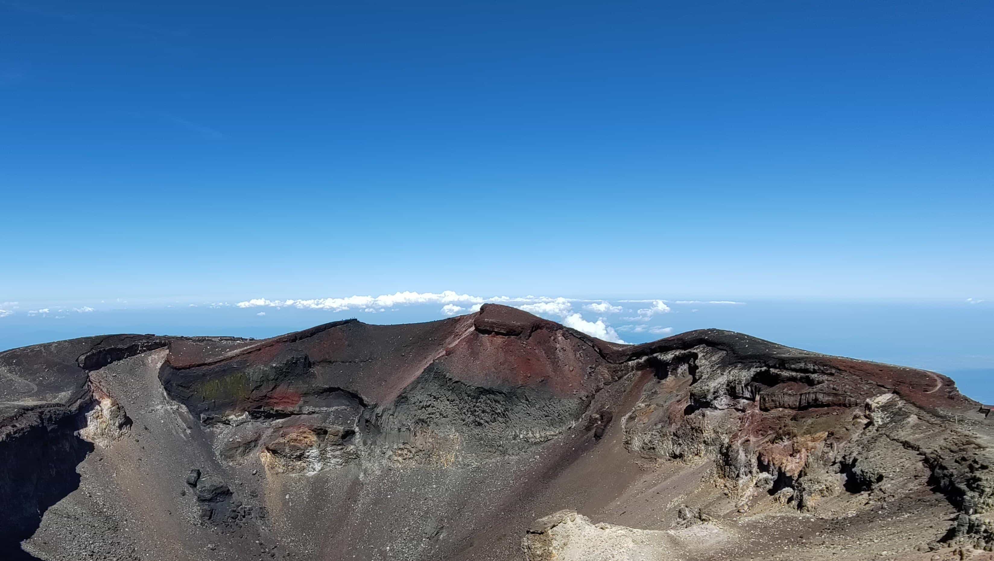
Not too long after, the gate marking the top came into view. I had now reached the rim of the crater, which I still wanted to circle once before making my way back down. I took a break at one of the stations close to the rim, sitting in the shadow of the building without moving for the next 30 minutes. Fun fact: they have a post office here:

It was also quite fun to look at the clouds from the side or above.

I took a quick inventory during my break: It was now 12:30 so I had taken 3.5h to reach this point. I had drunk half a liter in the first hour alone, and about 1.5 liters in total so far, which seemed like a good amount. I ate one of my onigiri during the break here, leaving me with 2 sandwiches for the way back. I didn't feel too exhausted, but no matter how much I rested, my heartbeat didn't slow much and my headache only got worse. I realized I probably just needed to get down to a lower elevation.

After 30mins rest, I started to make my way around the crater and eventually reached Kengamine (剣ヶ峰), the highest point of Japan. I had another hiker take a quick photo of me, took note of the guy playing Cello there (holy shit???) and then walked back around the other side of the crater.

I took in a final view of the surroundings, then I started to make my way down.

The Descent
The way down is a pure gravel path with a steady slope, separate from the route I hiked on the way up. Pretty boring really.

I consider myself to be a strong downhill hiker: e.g. when I descended Mount Tanzawa (丹沢山) I averaged 10km/h, which is faster than most untrained people jog. But for the first time, I actually got overtaken by other people, which didn't happen even once on the way up. The way down was also not particularly comfortable: I was half sliding down the loose gravel, had to stop every 20mins or more to remove a ton of stones from my hiking boots, and slipped and fell several times, like everyone else around me. In addition, I had a pretty strong headache at this point and felt like I had to throw up so badly that I couldn't go on and ended up paying for one of the mountain hut toilets just for that. After that though, I continued making my way down and reached the 5th station just fine.
I had unfortunately missed the last bus to Shinjuku Busta, so instead I had to take another bus to Kawaguchiko (河口湖) at the foot of the mountain. I wanted to take the bus from there to Shinjuku Busta, but it was already booked out, so I had an excruciating, long train ride for another 3h back to Shinjuku after that.
Overall, the hike took me almost 8h roundtrip, including breaks: 3.5h to climb up, 30mins break at the top, 1h to circle the crater, and then 2.5h down.
I got a hefty sunburn despite putting on sunscreen - perhaps I should have renewed it after I reached the top. My headaches also kept going for the next few days, so I am quite sure now that I didn't suffer only from altitude sickness but probably also had a sunstroke or similar. I am quite sensitive in that regard, 15mins of exposure to sunlight in the summer being enough to give me a headache for the rest of the day, but I always wear my trusty anti-UV hat to protect myself… perhaps the strong radiation near the peak of Mount Fuji was just too much for it.
All in all, the hike itself is relatively boring, especially the way down. Before I went, a friend told me, confusedly, that “Fuji is for looking (from a distance) not for going up” but the views, both from the flank of the mountain as well as from the top into the crater and over the surrounding area, were amazing too. I'm glad I was able to do this, though I feel like I'll have to go again at some point with more preparation, so I can truly experience the full classic: seeing the sunrise from the mountain peak.
But as it stands now, I'm happy I did this and proud of myself. Overall, I can recommend a Mount Fuji hike. Though you might be better off planning some more time for this than me.